

What is geofencing fleet management? A UK guide

If you think GPS tracking alone is enough to run a compliant, efficient fleet, you’re working with half the picture. What is geofencing fleet management? It’s the next layer: virtual boundaries drawn around depots, customer sites, or restricted zones that trigger automated alerts and actions the moment a vehicle crosses them. For UK operators navigating ULEZ penalties, DVSA scrutiny, and after-hours vehicle misuse, geofencing transforms raw location data into something far more useful — a real-time control system that works even when you’re not watching.
Table of Contents
- What is geofencing in fleet management?
- How geofencing enhances safety and regulatory compliance in UK fleets
- UK legal and data privacy considerations for geofencing fleet management
- Comparing geofencing with traditional GPS tracking and asset monitoring
- Implementing geofencing effectively in UK fleet operations
- Why geofencing is an operational control layer, not just tracking
- Explore Fleetalyse’s geofencing and telematics solutions for UK fleets
- Frequently asked questions
Key Takeaways
| Point | Details |
|---|---|
| Geofencing defined | Geofencing sets virtual GPS boundaries that trigger real-time alerts for better fleet control. |
| Safety and compliance benefits | UK fleets use geofencing to reduce unauthorised use and comply with emission zone regulations. |
| Data privacy compliance | UK GDPR mandates lawful basis, transparency, and retention policies for location tracking. |
| Technology distinctions | Geofencing enhances GPS tracking by adding operational rules and automation workflows. |
| Effective implementation | Reliable GPS data and behavioural learning reduce false alerts and improve system accuracy. |
What is geofencing in fleet management?
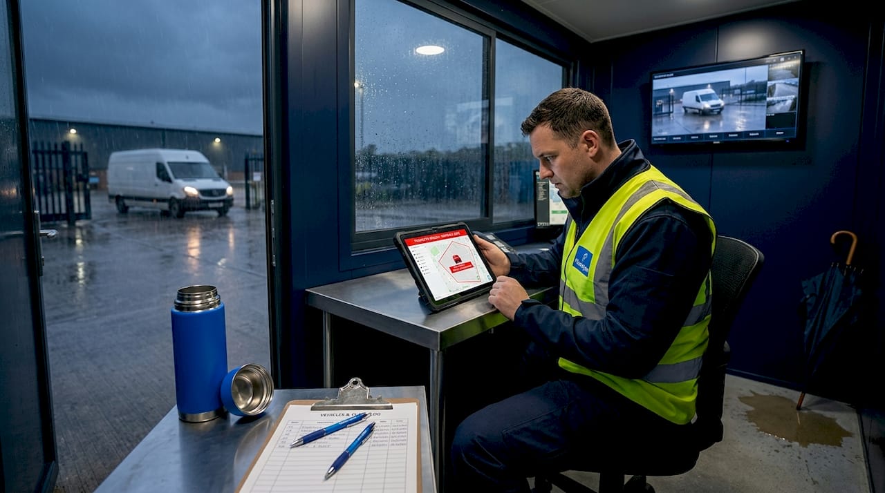
Geofencing is the practice of defining a virtual perimeter around a physical location using GPS coordinates, then configuring your fleet management software to respond automatically when a vehicle enters or exits that zone. It combines GPS fleet tracking with telematics hardware and rule-based software logic to create something GPS alone cannot deliver: automated, event-driven intelligence.
Here’s how the mechanics work in practice. Your telematics device reports the vehicle’s position continuously, typically every 10 to 60 seconds, with positional accuracy of around 5 to 10 metres on open roads. The fleet management platform compares each reported position against your configured zones. When a match occurs, it fires an alert, logs a timestamp, or triggers a workflow, such as notifying a dispatcher or updating a delivery record.
As geofencing specialists explain, geofencing uses GPS-defined virtual boundaries to trigger alerts and automate workflows in fleet management. The critical distinction from standard GPS tracking is that geofencing is proactive, not passive. Rather than reviewing where a vehicle went after the event, you receive actionable information as it happens.
Key technical capabilities geofencing adds to a fleet:
- Zone entry and exit alerts sent in real time to a nominated contact or system
- Dwell time monitoring that records how long a vehicle remained inside a site
- Automated timestamps for proof-of-delivery or compliance audit trails
- Triggered workflows such as customer notifications or tachograph record flags
Pro Tip: When setting up your first geofence, start with your depot perimeter. It’s the easiest win, giving you immediate visibility of unauthorised overnight vehicle movements without any complex configuration.
How geofencing enhances safety and regulatory compliance in UK fleets
With a clear grasp of geofencing basics, let’s explore how it drives concrete safety and compliance gains in UK fleets.
The benefits of geofencing fleet management extend well beyond knowing where your vehicles are. For UK operators, the real value sits at the intersection of security, regulatory compliance, and driver behaviour.
Preventing unauthorised use is one of the most immediate returns. When a vehicle moves outside a defined depot zone outside of scheduled hours, a geofence alert fires instantly. Fleets using geofencing report up to 74% reduction in unauthorised vehicle use within the first month, alongside significant reductions in idle fuel costs. That’s a substantial impact from a configuration that takes minutes to set up.
Urban zone compliance is increasingly critical for UK fleets operating in major cities. London’s Ultra Low Emission Zone (ULEZ) and Clean Air Zones in cities like Birmingham and Bristol carry daily penalty charges that accumulate rapidly for non-compliant vehicles. Geofencing enforces urban access compliance by alerting fleets when vehicles enter ULEZ or LEZ zones, allowing you to verify that only compliant assets are operating in those areas. For mixed fleets with older diesel vehicles alongside newer Euro VI trucks, this distinction matters enormously.
Route corridor enforcement adds another layer of protection for high-value cargo, hazardous goods vehicles, or operators with specific Operator Licence route conditions. A corridor geofence defines an acceptable path between two points. Any deviation, whether due to driver error, an opportunistic detour, or a navigation shortcut through a restricted road, triggers an alert before the situation compounds.
The compliance benefits of fleet telematics also extend to safe driving habits. Automated alerts that flag boundary breaches create an accountability loop. Drivers who know their geographic behaviour is monitored, not just their speed, demonstrably alter their conduct.
Key compliance use cases for UK fleets:
- After-hours depot movement alerts
- ULEZ, LEZ, and Clean Air Zone entry monitoring
- Restricted area enforcement for hazardous goods routes
- Customer site arrival and departure verification for SLA reporting
Pro Tip: Map your geofence zones against your Operator Licence undertakings. If your licence restricts operating hours or routes in certain areas, geofencing gives you documented evidence of compliance during DVSA audits.
UK legal and data privacy considerations for geofencing fleet management
Understanding the practical benefits of geofencing requires also navigating the important legal frameworks that govern UK fleet tracking.
Processing location data from vehicles driven by employees is not legally neutral territory. UK GDPR, the Data Protection Act 2018, and ICO guidance all apply directly to geofencing deployments. Getting this wrong exposes your organisation to enforcement action and employment disputes.
UK GDPR requires fleets to have a documented lawful basis for processing location data, a clear privacy notice, and a proportionate data retention policy. Most UK fleet operators rely on legitimate interests or contract performance as their lawful basis. Legitimate interests works where tracking is necessary for the fleet’s operational purposes and does not override the driver’s fundamental rights. Contract performance applies where monitoring is a condition of employment directly tied to job duties.
Additionally, location data processing is tightly regulated under PECR. Organisations must have lawful authority or consent, and must comply fully with Data Protection Act requirements when capturing and storing vehicle position data.
Transparency is non-negotiable. Your privacy notice must specifically cover what data is collected, why it is collected, how long it is retained, and who can access it. A generic employee handbook clause is not sufficient.
A practical compliance checklist for UK fleet geofencing:
- Document your lawful basis for each type of location processing (tracking, geofencing, journey history)
- Issue a specific privacy notice to all drivers and vehicle operators before deployment
- Set retention periods proportionate to purpose, typically 30 to 90 days for operational data
- Restrict access to location records to authorised personnel only
- Conduct a Data Protection Impact Assessment (DPIA) if the monitoring is large-scale or intrusive
Connecting this to your GPS tracking devices for legal compliance is straightforward when the hardware and software platform you choose supports configurable data retention and access controls from the outset.
Comparing geofencing with traditional GPS tracking and asset monitoring
Having reviewed legal and operational context, it’s useful to clearly contrast geofencing with related tracking technologies to understand their distinct roles.
Many fleet managers use the terms interchangeably, but GPS tracking, geofencing, and asset tracking serve different operational functions. Understanding the distinction helps you select the right tool for each challenge.
GPS tracking passively monitors vehicle location over time, providing route history and live position. Geofencing adds rule-based, proactive alerts triggered by boundary events, giving you operational control rather than just observation.
![]()
| Feature | GPS tracking | Geofencing | Asset tracking |
|---|---|---|---|
| Primary function | Records vehicle location continuously | Triggers alerts on zone entry/exit | Monitors trailers and equipment |
| Alert capability | None by default | Real-time boundary alerts | Movement and tamper alerts |
| Automation | Journey logging | Workflows, timestamps, notifications | Utilisation and dwell reports |
| Best use case | Route review and driver history | Compliance, security, delivery proof | Trailer management and theft prevention |
| Data output | Coordinates and speed over time | Events with timestamps and locations | Asset position and status |
For GPS and geofencing integration, the most capable platforms combine all three layers into a single view. Here’s how the three technologies work together in a typical HGV operation:
- GPS tracking records the full journey from depot to delivery point, capturing speed, route, and driving time for tachograph cross-referencing.
- Geofencing fires an alert when the vehicle enters the customer delivery zone, automatically logging an arrival timestamp for proof-of-delivery.
- Asset tracking on the trailer records when it was uncoupled and how long it remained on-site, supporting utilisation reporting and theft prevention.
Each layer adds a dimension of control that the others cannot provide alone.
Implementing geofencing effectively in UK fleet operations
With clear distinctions and compliance basics established, let’s explore practical steps to roll out geofencing successfully within your fleet.
The technology is only as good as its configuration. Poorly set up geofences generate constant false alerts, erode driver trust, and cause managers to disable notifications entirely, which defeats the purpose entirely.
Start with hardware quality. Reliable geofence event detection depends on good GPS/GNSS positional accuracy and frequent data reporting, ideally every 10 to 60 seconds. Devices with poor signal acquisition in urban canyons or high-latency reporting will miss boundary crossings or flag them late, which undermines confidence in the system. Choosing telematics hardware options with strong GNSS receivers and configurable reporting intervals is the foundation of a reliable deployment.
Four implementation best practices for UK fleets:
- Allow a behavioural learning period of two to three weeks before treating alerts as actionable. During this time, observe legitimate route variations, common stop locations, and normal operating patterns. Use these observations to refine zone boundaries and exclude known false-positive locations.
- Configure time-based geofences that activate only during relevant hours. A depot security zone that triggers during working hours is noise. The same zone triggering between 11pm and 5am is a genuine security alert.
- Use predictive alerting where your platform supports it. Rather than notifying a dispatcher after a vehicle has already entered a restricted zone, set a buffer zone slightly outside the restricted boundary so intervention is possible before the breach occurs.
- Review alert logs monthly and retire or adjust zones that consistently generate unactioned alerts. A geofence that nobody responds to is administrative overhead, not a control mechanism.
Pro Tip: Assign geofence alerts to a specific role, not a named individual. If the nominated recipient changes job, alerts go unread. Role-based notification routing ensures continuity regardless of staff changes.
Why geofencing is an operational control layer, not just tracking
Most fleet managers first encounter geofencing as a bolt-on to their GPS system, a way to get notified when a van leaves the depot overnight. That’s understandable, but it significantly undersells what the technology actually does.
The more instructive framing is this: traditional GPS tracking is a record of what happened. Geofencing is a response to what is happening. That distinction changes everything about how you design your operations around it. When an alert fires as a vehicle approaches a ULEZ boundary, you have a window to intervene. When the tachograph flags a driving hours concern and the geofence simultaneously shows the vehicle is 40 miles from its expected location, you have the context to act decisively rather than investigate after the fact.
What we consistently see across UK fleets is that the operators who extract the most value from geofencing are those who integrate it with their compliance workflows rather than treating it as a standalone alert tool. When geofence events feed into driver behaviour scoring, audit logs, and customer service records simultaneously, the technology multiplies its impact across every dimension of fleet performance.
There’s also an honest conversation to be had about alert fatigue. Geofencing deployed without configuration discipline creates noise that managers learn to ignore. The answer is not fewer geofences but smarter ones: time-based activation, behavioural baselines, and predictive buffers as discussed earlier. Investing a few hours in configuration setup returns months of reliable, low-noise intelligence.
The fleet managers who treat geofencing as an operational control layer gain something that pure GPS tracking cannot offer: the ability to prevent problems rather than document them. Security, safety, compliance, and customer service all improve simultaneously, because the system is actively working on your behalf rather than simply recording events for later review.
Explore Fleetalyse’s geofencing and telematics solutions for UK fleets
If this guide has clarified what geofencing fleet management can do for your operation, the next step is finding a platform built to deliver it in a UK compliance context.
Fleetalyse offers an integrated telematics platform with geofencing capabilities designed specifically for UK commercial fleet operators. Whether you’re managing HGVs, vans, or mixed assets, the platform supports real-time zone alerts, audit-ready event logs, and driver behaviour monitoring, all within a framework built for DVSA and Operator Licence compliance. Hardware options include both hardwired and OBD-II plug-and-play devices for flexible installation. You can explore the full range of GPS tracking devices and accessories directly, with a free tier available for smaller fleets and scalable plans for larger operations. UK-based support means you get practical guidance from people who understand your regulatory environment.
Frequently asked questions
What is the difference between GPS tracking and geofencing in fleet management?
GPS tracking passively records vehicle locations and route history over time, while geofencing sets virtual boundaries that trigger alerts on crossing, enabling real-time operational control rather than retrospective review.
How does geofencing help UK fleets comply with low emission zone regulations?
Geofencing alerts fleets entering ULEZ or Clean Air Zones in real time, enabling dispatch to verify that only compliant vehicles operate in those areas and avoid daily penalty charges.
What are the key data privacy requirements for geofencing in the UK?
Fleets must establish a documented lawful basis for location data processing, issue a specific privacy notice to all drivers, and maintain proportionate data retention and deletion policies in line with UK GDPR and ICO guidance.
How often should GPS data be reported for accurate geofencing?
GPS location data should be reported every 10 to 60 seconds to ensure timely and reliable detection of geofence boundary events, minimising missed or delayed alerts in live fleet operations.